Diminutive Deep Sea Drone Dives for Wrecks and Reefs

The global ocean is difficult to explore—the common refrain is that we know less about the deep ocean than we do about the surface of the moon. Australian company Advanced Navigation wants to change that with a pint-sized autonomous underwater vehicle (AUV) that it hopes will become the maritime equivalent of a consumer drone. And the new AUV is already getting to work mapping and monitoring Australia’s coral reefs and diving for shipwrecks.
The Sydney-based company has been developing
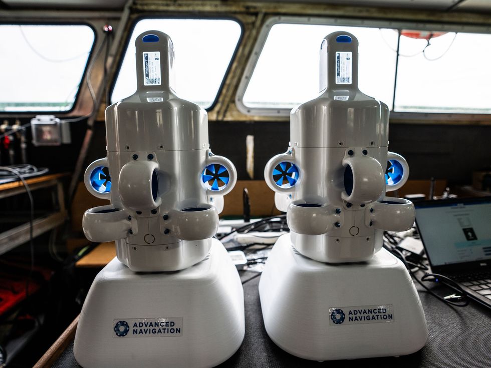
underwater navigation technology for more than a decade. In 2022, Advanced Navigation unveiled its first in-house AUV, called Hydrus. At less than half a meter long, the vehicle is considerably smaller than most alternatives. Even so, it’s fully autonomous and carries a 4k-resolution camera capable of 60 frames per second that can both capture high-definition video and construct detailed 3D photogrammetry models.
Advanced Navigation says Hydrus—with a depth rating of 3,000 meters, a range of 9 kilometers, and a battery that lasts up to three hours—is capable of a wide variety of missions. The company recently sold two units to the Australian Institute of Marine Science (AIMS), the country’s tropical marine science agency, which will use them to survey coral reefs in the North West Shelf region off the country’s west coast. Hydrus has also recently collaborated with the Western Australian Museum to produce a detailed 3D model of a shipwreck off the coast near Perth.
“If people can go and throw one of these off the boat, just like they can throw a drone up in the air, that will obviously benefit the exploration of the sea.” —Ross Anderson, Western Australian Museum
After many years of supplying components to other robotics companies,
Peter Baker, subsea product manager at Advanced Navigation, says they company spotted a gap in the market. “We wanted to take the user experience that someone would have with an aerial drone and bring that underwater,” he says. “It’s very expensive to get images and data of the seabed. So by being able to miniaturize this system, and have it drastically simplified from the user’s point of view, it makes data a lot more accessible to people.”
But building a compact and low-cost AUV is not simple. The deep ocean is not a friendly place for electronics, says Baker, due to a combination of high pressure and corrosive seawater. The traditional way of dealing with this is to stick all the critical components in a sealed titanium tube that can maintain ambient pressure and keep moisture out. However, this requires you to add buoyancy to compensate for the extra weight, says Baker, which increases the bulk of the vehicle. That means bigger motors and bigger batteries. “The whole thing spirals up and up until you’ve got something the size of a minibus,” he says.
Advanced Navigation got around the spiral by designing bespoke pressure-tolerant electronics. They built all of their circuit boards from scratch, carefully selecting components that had been tested to destruction in a hydrostatic pressure chamber. These were then encapsulated in a water-proof composite shell, and to further reduce the risk of water ingress the drone operates completely wirelessly. Batteries are recharged using inductive charging and data transfer is either over
Wi-Fi when above water or via an optical modem when below the surface.

Hydrus AUVs are charged using induction to keep corrosive seawater from leaking in through charging ports.Advanced Navigation
This has allowed the company to significantly miniaturize the system, says Baker, which has a drastic impact on the overall cost of operations. “You don’t need a crane or a winch or anything like that to recover the vehicle, you can pick it up with a fishing net,” he says. “You can get away with using a much smaller boat, and the rule of thumb in the industry is if you double the size of your boat, you quadruple the cost.”
Just as important, though, is the vehicle’s ease of use. Most underwater robotics systems still operate with a tether, says Baker, but Hydrus carries all the hardware required to support autonomous navigation on board. The company’s “bread and butter” is inertial navigation technology, which uses accelerometers and gyroscopes to track the vehicle from a known starting point. But the drone also features a sonar system that allows it to stay a set distance from the seabed and also judge its speed by measuring the Doppler shift on echoes as they bounce back.
This means that users can simply program in a set of way points on a map, toss the vehicle overboard and leave it to its own devices, says Baker. The Hydrus does have a low-bandwidth
acoustic communication channel that allows the operator to send basic commands like “stop” or “come home,” he says, but Hydrus is designed to be a set-and-forget AUV. “That really lowers the thresholds of what a user needs to be able to operate it,” he says. “If you can fly a DJI drone you could fly a Hydrus.”
The company estimates for a typical seabed investigation in water shallow enough for human divers, the Hydrus could be 75 percent cheaper than alternatives. And the savings would go up significantly at greater depths. What’s more, says Baker, the drone’s precise navigation means it can produce much more consistent and repeatable data.
To demonstrate its capabilities, Hydrus’ designers went hunting for shipwrecks in the
Rottnest ships graveyard just off the coast near Perth, in Western Australia. The site was a designated spot for scuttling aging ships, says Ross Anderson, curator at Western Australian Museum, but has yet to be fully explored due to the depth of many of the wrecks.
The Advanced Navigation team used the Hydrus to create a detailed 3D model of a sunken “coal hulk”—one of a category of old iron sailing ships that were later converted to floating coal warehouses for steamships. The Western Australian Museum has been unable to identify the vessel so far, but Anderson says these kind of models can be hugely beneficial for carrying out maritime archaeology research, as well as educating people about what’s below the waves.
Advanced Navigation used its new Hydrus drone to create a detailed 3D image of an unidentified “coal hulk” ship in the Rottnest ships graveyard off the western coast of Australia.
Advanced Navigation
Any technology that can simplify the process is greatly welcomed, Anderson adds. “If people can go and throw one of these off the boat, just like they can throw a drone up in the air, that will obviously benefit the exploration of the sea,” he says.
Ease of use was also a big driver behind AIMS’s purchase of two Hydrus drones, says technology development program lead
Melanie Olsen, who is also an IEEE senior member. Most of the technology available for marine science is still research-grade and a long way from a polished, professional product.
“When you’re an operational agency like AIMS, you typically don’t have the luxury of spending a lot of time on the back of the boat getting equipment ready,” says Olsen. “You need something that users can turn on and go and it’s just working, as time is of the essence.”
Another benefit of the Hydrus for AIMS is that the drone can operate at greater depths than divers and in conditions that would be dangerous for humans. “Its enabling our researchers to see further down in the water and also operate in more dangerous situations such as at night, or in the presence of threats such as crocodiles or sharks, places where we just wouldn’t be able to collect that data,” says Olsen.
The agency will initially use the drones to survey reefs on Australia’s North West Shelf, including Scott Reef and Ashmore Reef. The goal is to collect regular data data on coral health to monitor the state of the reefs, investigate how they’re being effected by climate change, and hopefully get early warning of emerging problems. But Olsen says they expect that the Hydrus will become standard part of their ocean monitoring toolkit going forward.
This story was updated on 11 March 2024 to correct the year when Advanced Navigation unveiled Hydrus.


